We say Earth is a sphere. But it's not exactly a perfect one.
It's an oblate spheroid that bulges at the equator and is somewhat squashed at the poles.
In fact, it bulges about 14 miles out more at the equator compared to pole-to-pole.
Because of the field of geodesy, we've gained a much better understanding of the shape of our planet. Let's delve into this a little deeper.
1. What is an Ellipsoid in GIS?
Geodesists have adopted an ellipsoid model to determine latitude and longitude coordinates. The major axis of an ellipse is the equatorial radius. The minor axis is from the poles to the center.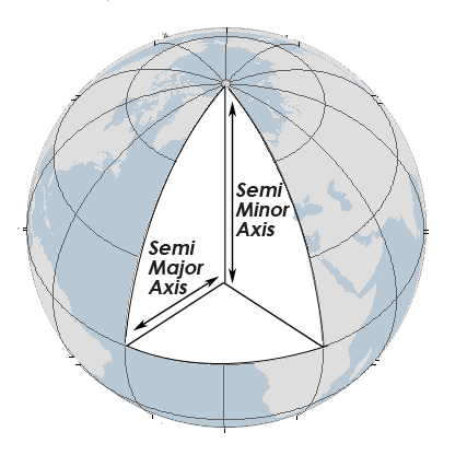
The most common reference ellipsoid in cartography and surveying is the World Geodetic System (WGS84). The Clarke Ellipsoid of 1866 was recomputed for the North American Datum of 1927 (NAD27).
When comparing NAD27 and NAD84, latitude and longitude coordinates can be displaced to the degree of tens of meters (with the same latitude and longitude coordinates). The image below shows an exaggerated semi-major axis and semi-minor axis.
2. How Do Horizontal Datums Relate to Ellipsoids?
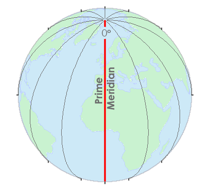
Horizontal datums give us the capability to measure distances and directions across the surface of the earth. Most horizontal datums define a zero line at the equator from which we measure north and south (latitudes).There is also a zero line at the Greenwich Meridian from which we measure east and west (longitudes). This standardized reference point simplifies navigation and geographic coordination, serving as a fundamental reference for global positioning and mapping systems.
We reference all coordinates to a datum. This datum serves as a crucial baseline for establishing the accurate positions of geographic features and ensuring consistency in spatial data analysis and interpretation.
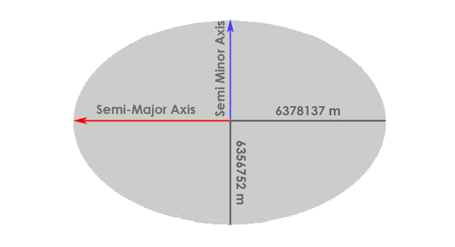
A datum describes the shape of the Earth in mathematical terms. A datum defines the radius, inverse flattening, semi-major axis, and semi-minor axis for an ellipsoid.
Here is the WGS84 datum:
- Semi-major axis: 6,378,137.0 m
- Semi-minor axis: 6,356,752.3142 m
- Inverse flattening: 298.257223563
| Name | Year | Semi-Major Axis (Equator Radius) | Semi-Minor Axis (Polar Radius) | Users |
|---|---|---|---|---|
| Clarke | 1866 | 6,378,206.4 m | 6,356,583.8 m | North America |
| International (Hayford) Ellipsoid | 1924 | 6,378,388.0 m | 6,356,911.9 m | Most of the World |
| WGS72 | 1972 | 6,378,135.0 m | 6,356,750.5 m | NASA |
| GRS80 | 1980 | 6,378,137.0 m | 6,356,752.3 m | Worldwide |
| WGS84 | 1984 | 6,378,137.0 m | 6,356,752.3 m | Current Worldwide |
3. Rotational Forces Flatten the Earth
Sir Isaac Newton proposed that the Earth flattens at the poles because of rotational forces. As the Earth spins on its axis, the centrifugal force causes the Earth to bulge out at the equator. This is why the Earth is better modeled as an ellipsoid, which is a sphere slightly flattened at the poles.In the 19th and 20th centuries, different ellipsoids were adopted in various parts of the world. Surveys were being performed on different continents. Each survey produced different ellipsoidal parameters.
For example, surveys in Australia yielded the “best” ellipsoid, which was different from South America and Asia. There wasn’t a unifying global ellipsoid. Each continental survey was isolated with its own ellipsoid parameters.
There was no clear way to combine these global survey measurements. There was a scarcity of survey points in specific areas and a lack of computational resources that prevented a global ellipsoid.
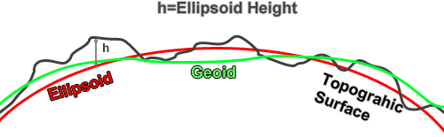
4. Fitting the Ellipsoid with the Geoid
A horizontal coordinate system gives us our latitude and longitude. On the other hand, a vertical datum is another component of your typical horizontal coordinate system.We are on a three-dimensional planet that has ups and downs in addition to the side-to-side in a horizontal coordinate system on the surface. To handle the ups and downs, we have the vertical datum which gives a place to put zero measurements. Mean sea level is often understood as the basis for our ups and downs. This is called the geoid.
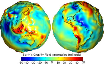
Vertical datums are lumpy and irregular. This is because of the varying densities in the Earth in different places. There are gravity anomalies such as mountainous areas having more mass.
This means that the mean sea level is not as smooth as everyone thinks it is. Geoids are not constant and they differ from place to place. They have undulations as you move around on the Earth.
The Earth is not as round as we like to pretend it is. We have lumps or undulations on them as they come back to us in the form of a geoid. The geoids put the lumps back into our nice smooth horizontal datum coordinate system.
5. The Varying Historical Accuracy of the Ellipsoid
Earth bulges out more at the equator than at the poles by about 70,000 feet. Since the beginning of the 19th century, scientists have repeatedly calculated the dimensions of the ellipsoid with considerably different accuracy.The early attempts at measuring the ellipsoid used small amounts of data and did not represent the true shape of the Earth. In 1880, the Clarke ellipsoid was adopted as a basis for its triangulation computations.
The first geodetic datum adopted for the United States was based on the Clarke ellipsoid with its starting point in Kansas known as Meade's Ranch… and now we have geocentric datums like WGS84 and NAD83 with their major and minor axis.