What is the central meridian?
The central meridian is the centerline of longitude for projection systems.Projected coordinate systems often use it as a reference point for an x-origin.
For example, the state plane and UTM projection systems use a central meridian.
Here are some examples of the central meridian in coordinate systems.
1. Lines of longitude run north-south

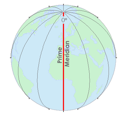
For example, the prime meridian is a line of longitude at 0°. Everything along this line has a 0° longitude coordinate.
But the prime meridian (Greenwich meridian) is specific to 0° longitude. Just like how the equator separates north and south, the Greenwich meridian separates east and west.
Projection systems use lines of longitude like the prime meridian. Just like how the prime meridian splits east and west, central meridians do the same thing.
2. UTM systems use a central meridian

This central meridian is an arbitrary value convenient for avoiding any negative easting coordinates. All easting values east and west of the central meridian will be positive.
Each UTM zone is 6° wide. So for UTM zone 31, it ranges from 0°E to 6°E longitude. Then, UTM zone 32 is from 6°E to 12°E with a central meridian of 9°E.
The Transverse Mercator takes a cylinder and places it on its side (rotates it 90°). Then, the cylinder intersects the ellipsoid along with two small circles parallel to the central meridian.
3. State Plane Coordinate Systems use a central meridian
Depending on the size and shape of a state, the State Plane Coordinate System (SPCS) uses 1 of 3 projection systems:- Transverse Mercator
- Lambert Conformal Conic
- Hotine Oblique
For zones that are long in the north-south direction, it uses a Transverse Mercator projection. Just like the UTM system, it has a central meridian and two small circles.


4. Where is the central meridian?
The central meridian depends on which projection system you use.For example, each UTM zone uses the central meridian as an origin for X-coordinates (eastings).
Everything in the central meridian is assigned a value of 500,000 m.
This means that the UTM system has 60 central meridians for all of its UTM zones.
5. UTM Zones
Here is a list of all the UTM zones including the central meridian and the extent of the UTM zone.| UTM Zone | Central Meridian | UTM Zone Extent |
|---|---|---|
| 1 | 177°W | 180°W-174°W |
| 2 | 171°W | 174°W-168°W |
| 3 | 165°W | 168°W-162°W |
| 4 | 159°W | 162°W-156°W |
| 5 | 153°W | 156°W-150°W |
| 6 | 147°W | 150°W-144°W |
| 7 | 141°W | 144°W-138°W |
| 8 | 135°W | 138°W-132°W |
| 9 | 129°W | 132°W-126°W |
| 10 | 123°W | 126°W-120°W |
| 11 | 117°W | 120°W-114°W |
| 12 | 111°W | 114°W-108°W |
| 13 | 105°W | 108°W-102°W |
| 14 | 99°W | 102°W-96°W |
| 15 | 93°W | 96°W-90°W |
| 16 | 87°W | 90°W-84°W |
| 17 | 81°W | 84°W-78°W |
| 18 | 75°W | 78°W-72°W |
| 19 | 69°W | 72°W-66°W |
| 20 | 63°W | 66°W-60°W |
| 21 | 57°W | 60°W-54°W |
| 22 | 51°W | 54°W-48°W |
| 23 | 45°W | 48°W-42°W |
| 24 | 39°W | 42°W-36°W |
| 25 | 33°W | 36°W-30°W |
| 26 | 27°W | 30°W-24°W |
| 27 | 21°W | 24°W-18°W |
| 28 | 15°W | 18°W-12°W |
| 29 | 9°W | 12°W-6°W |
| 30 | 3°W | 6°W-0° |
| 31 | 3°E | 0°-6°E |
| 32 | 9°E | 6°E-12°E |
| 33 | 15°E | 12°E-18°E |
| 34 | 21°E | 18°E-24°E |
| 35 | 27°E | 24°E-30°E |
| 36 | 33°E | 30°E-36°E |
| 37 | 39°E | 36°E-42°E |
| 38 | 45°E | 42°E-48°E |
| 39 | 51°E | 48°E-54°E |
| 40 | 57°E | 54°E-60°E |
| 41 | 63°E | 60°E-66°E |
| 42 | 69°E | 66°E-72°E |
| 43 | 75°E | 72°E-78°E |
| 44 | 81°E | 78°E-84°E |
| 45 | 87°E | 84°E-90°E |
| 46 | 93°E | 90°E-96°E |
| 47 | 99°E | 96°E-102°E |
| 48 | 105°E | 102°E-108°E |
| 49 | 111°E | 108°E-114°E |
| 50 | 117°E | 114°E-120°E |
| 51 | 123°E | 120°E-126°E |
| 52 | 129°E | 126°E-132°E |
| 53 | 135°E | 132°E-138°E |
| 54 | 141°E | 138°E-144°E |
| 55 | 147°E | 144°E-150°E |
| 56 | 153°E | 150°E-156°E |
| 57 | 159°E | 156°E-162°E |
| 58 | 165°E | 162°E-168°E |
| 59 | 171°E | 168°E-174°E |
| 60 | 177°E | 174°E-180°E |
Table of contents
- Latitude, Longitude and Coordinate System Grids
- Where is the Central Meridian?
- Greenwich Meridian (Prime Meridian)
- Lost in Null Island: The Curious Origin of 0,0
- Degrees/Minutes/Seconds (DMS) vs Decimal Degrees (DD)
- What is a Horizontal Datum Reference Frame?
- Vertical Datum – Earth's Elevation Reference Frame
